


Millions Brace for Intense Storms Across Midwest and Southern States
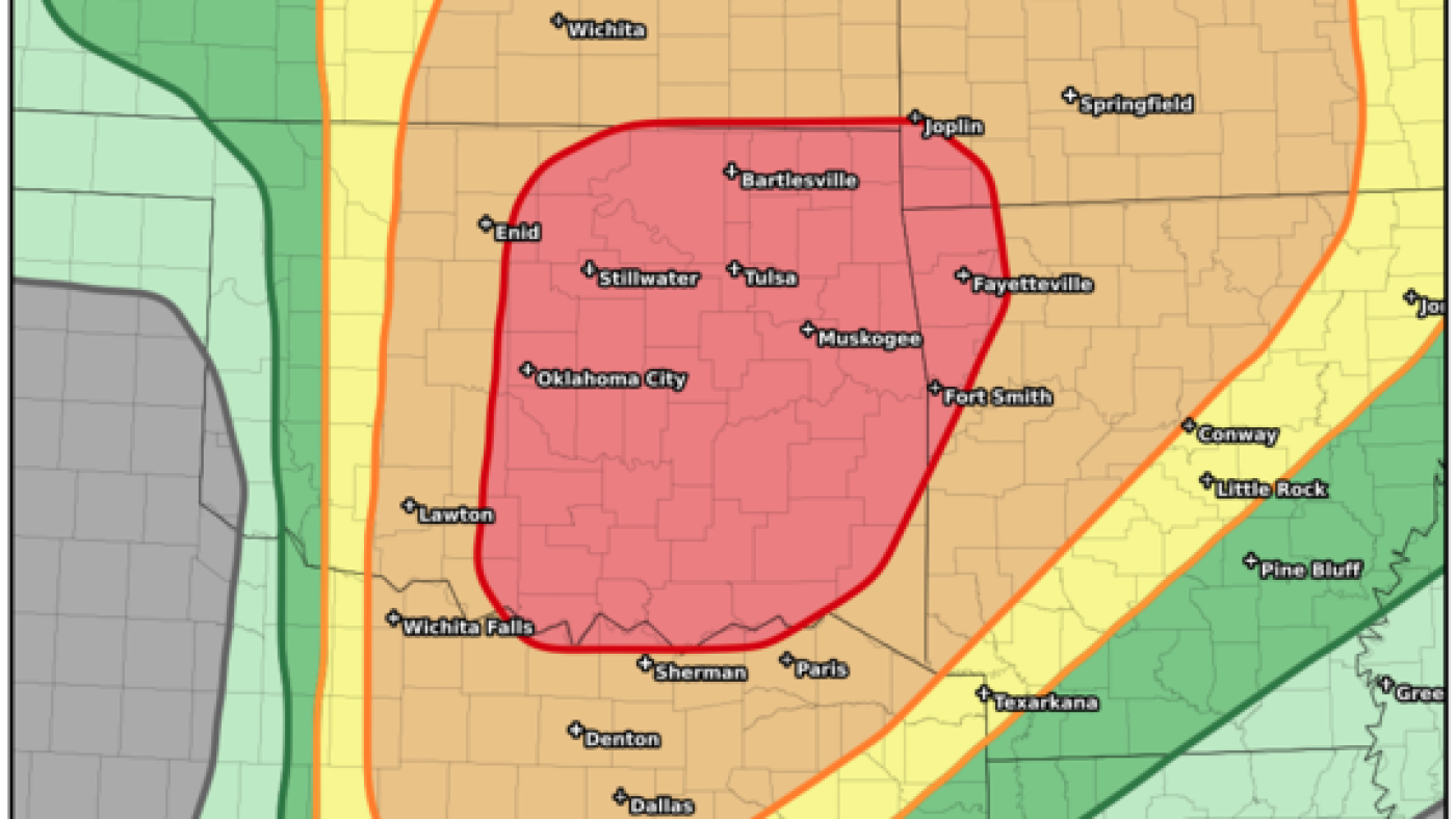
The National Weather Service has identified central and eastern Oklahoma, including Oklahoma City and Tulsa, as well as Kansas, as being most vulnerable to severe weather conditions expected on Monday.
Following a weekend of destructive storms impacting numerous states, another perilous weather pattern is forecasted for the Midwest beginning Monday and shifting to the Southeast by Tuesday. Recovery efforts are ongoing from the recent deadly onslaught.
An evolving storm system in the central United States is set to generate yet another wave of hazardous severe weather, with a focus on eastern Oklahoma and the Ozarks. Broadly, substantial rainfall is anticipated from the northern Plains stretching down to North Texas.
Storm Risks and Projections
The threat level for multiple severe thunderstorms across central and eastern Oklahoma and far northwest Arkansas has been rated at a significant 4 out of 5 by the National Weather Service. These conditions present a considerable risk to millions of residents in these areas.
Forecast models suggest a swift escalation of these storms, which are predicted to unleash powerful winds, significant hail, and intense tornado activity. By mid-afternoon Monday, Oklahoma City, Tulsa, and several regions in Kansas are expected to face the brunt of the storms.
Impact of Recent Storms and Preparations
In the aftermath of the recent tumultuous weather, Kentucky stands out as one of the hardest impacted. A tornado with estimated wind speeds near 150 mph wreaked havoc, leaving destruction in its path. Tragically, 19 fatalities have been confirmed, with the death of a woman recently added to the toll. Several individuals remain hospitalized due to storm-inflicted injuries.
Communities are in recovery mode, clearing the rubble of collapsed edifices and fixing what has been damaged, all while preparing for potential impending storms.
Future Forecast and Areas of Concern
As Monday night wanes, the severe weather in Oklahoma and Kansas is predicted to migrate east, affecting regions like the Mississippi, Ohio, and Tennessee Valleys, and reaching Kentucky by Tuesday.
The National Weather Service has flagged Western Kentucky, Tennessee, along with northern Mississippi and Alabama, as high-risk zones for intense thunderstorms accompanied by torrential rains.
Leave a Reply