


Major US Cities Facing Sinking Ground Threats
Recent findings from satellite data reveal that the terrain beneath America’s largest cities is gradually subsiding—a crisis called subsidence—which poses a risk of structural damage and increased flooding.
This morphological change of urban ground levels is perilous for infrastructure. Without intervention, it could lead to significant challenges, notably increased flooding hazards.
Manoochehr Shirzaei, a geophysicist from Virginia Tech, disclosed that the extent of land subsidence exceeded expectations. He collaborated on a newly published study in Nature Cities, employing satellite data to meticulously track minor vertical shifts in urban landscapes across the US.
The research highlighted that city centers are descending at faster rates than surrounding suburban areas, heightening the risk of structural degradation.
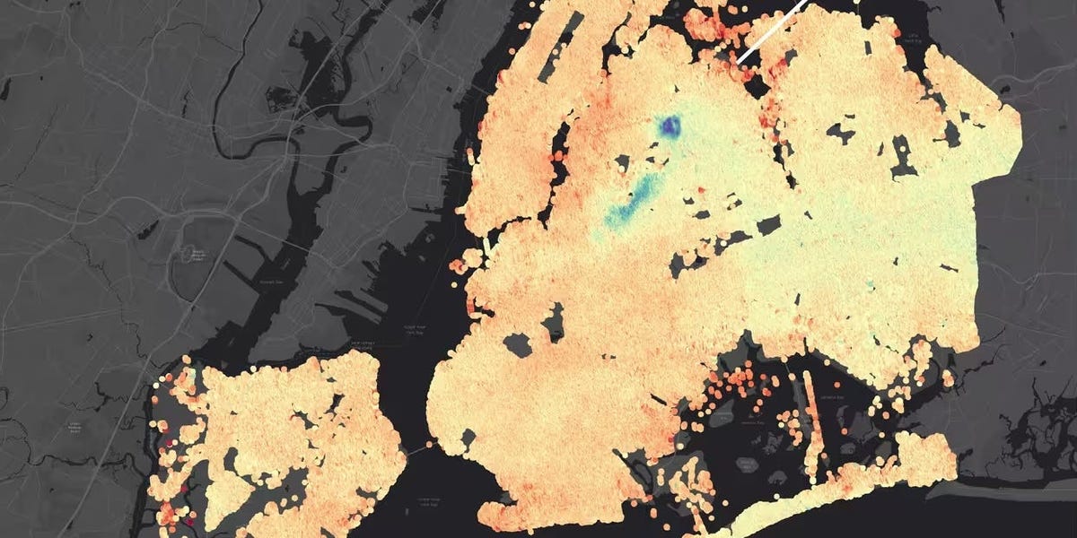
The study revealed subsidence in 28 major cities, including places like Seattle, San Diego, Denver, Dallas, Chicago, and notably, New York City.
These areas collectively host around 34 million people, who are potentially at risk.
Consequences of Uneven Ground Settlement
As sea levels climb, the sinking of coastal urban areas can exacerbate flood risks. Inland cities are not immune, facing the possibility of forming low-lying basins prone to water accumulation during storms.
Houston, taking the lead in subsidence rates, shows 40% of its terrain sinking by five millimeters annually, with certain areas facing subsidence of up to two inches per year. Shirzaei's earlier findings linked this to water stagnation post-Hurricane Harvey.
Localized subsidence, where sections of land move at different rates, can lead to severe infrastructural stress.
A notorious example is New Orleans' Louis Armstrong International Airport, where uneven ground has resulted in cracked pavement and waterlogged taxiways.
Such inconsistencies in ground settlement can lead to the tilting of structures, foundation cracks, and weakened bridges. Alone, subsidence might not pose an immediate critical risk, but in combination with adverse weather and inadequate building codes, it could become hazardous, according to Shirzaei.
High-Risk Zones: 29,000 Buildings Threatened
Approximately 29,000 buildings are deemed at risk, despite uneven subsidence affecting just 1% of the surveyed urban areas.
A silver lining is the confinement of these risks to small, well-defined city regions, allowing for targeted preventive measures.
Leonard Ohenhen, from Columbia’s Lamont-Doherty Earth Observatory, emphasized the necessity for urgent interventions in these critical zones to strengthen infrastructure resilience.
Understanding the Causes Behind Subsidence
The principal driver of subsidence is identified as groundwater extraction, suggesting that improved groundwater management could mitigate sinkage rates.
Other contributors include oil and gas withdrawals in regions like Texas, further depleting subsurface support in a manner similar to water extraction.
The tremendous mass of urban buildings exacerbates ground depression, as noted in a New York City-focused study from 2023.
Some areas continue to settle due to geological responses to ancient ice sheets, which altered land elevations thousands of years ago. This phenomenon affects places such as New York, Indianapolis, Nashville, Philadelphia, Denver, Chicago, and Portland.
Additionally, heat generated by city activity in Chicago and construction vibrations in Miami have also been implicated in exacerbating subsidence.
Leave a Reply